
Thane Urban Flood Alert Network (TUFAN)
About Urban LEDS project
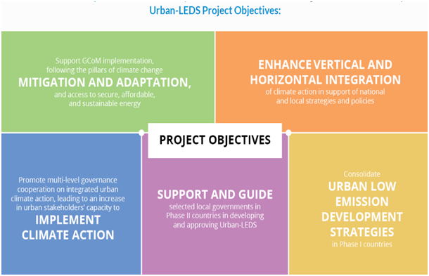
UN-Habitat and ICLEI are supporting more than 60 local governments worldwide tackling climate change by accelerating urban low emission development and climate change resilience for their communities, through a multilevel governance approach to integrated urban climate action.
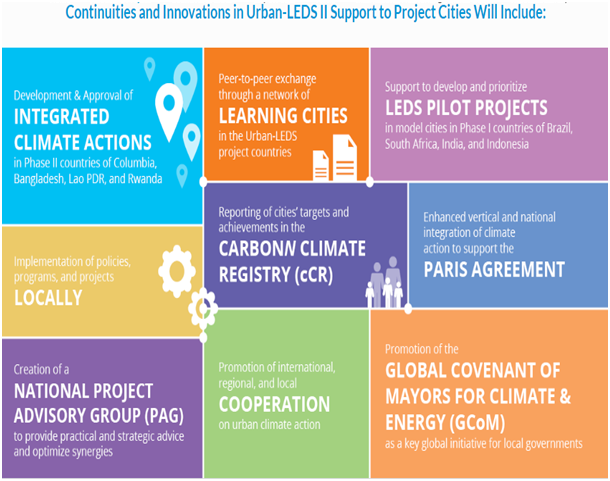
During 2012 – 2015 under the Urban-LEDS I project, ICLEI and UN-Habitat supported eight model cities in Brazil, India, Indonesia and South Africa to develop comprehensive Urban Low Emission Development Strategies and action plans using ICLEI’s GreenClimateCities (GCC) process methodology. In 2017, a second phase of the project was launched (Urban-LEDS II). This new phase includes the addition of 23 model and satellite cities, and activities expanding into Colombia, Bangladesh, Lao PDR, and Rwanda.
While the core objective remains to contribute to the reduction of greenhouse gas emissions through the development of eight brand new city-level Urban Low Emission Development Strategies, a strengthened focus on adaptation and climate resilience will ensure a comprehensive climate and development approach.
To know more please visit https://urban-leds.org/
About the pilot scale implementation in Thane
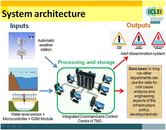
Vulnerability Assessment of the city for climate change and its impact showed that the city will face frequent short duration high intensity rainfall events in future. To increase the climate resilience of the city a feasibility study to assess the potential of IoT based early warning system for water logging was conducted. Flood warning is an important non-structure measure for minimizing loss of lives, properties and assists the authorities concerned, in prompt and effective response during and after floods.
Runoff from the Thane city is disposed into Thane Creek and Ulhas River Estuary. These two water bodies are tidally influenced and impact of tidal water in drain/nalla is also observed. For Thane Creek, time lag of more than 30 minutes was observed for high tide between Trombay and Thane Salt pan with considerable water level difference. For Ulhas River Estuary, time lag of a high tide between Vasai Basin and Kasheli Bridge was observed about an hour with considerable water level difference. In a present scenario, Disaster manager has to be depended on the Maharashtra Maritime Board tide level data, which is available only 6 hour internal i.e., for high tide and low tide. High tidal level alert during heavy rains will help city manages to plan the rescue measures and manage traffic.
Owing to this it is crucial to set a real-time water level monitoring for Thane Creek and Ulhas River Estuary to acquire real-time tidal water levels. This will aid city and disaster managers to issue an alert and plan rescue measures during high intensity rainfall event coinciding with high tide.
Maximum number of water logging has been observed in low lying areas during the high intensity rainfall events coinciding with high tide. Rainfall intensity of various rainy days, design aspects of major nallas/drains and tidal ingress in nalla has been studied under this assessment.
On pilot scale, nalla No.3 East and West has been selected for detailed study and found considerable tidal ingress influencing free flow of storm water from Vandana Theatre, Ram Maruti Road, Gadkari Rangayatan and Thane College area. However considering inter-linkages of nallahs, storm water drains, tidal impacts, low laying areas it is proposed to monitor water levels at 3 more nallah.
For nalla number 3, based on last 20-25 minutes rainfall data, the real-time nallah and tidal water levels it is proposed to be forecasted. On an average about 20-25 minutes early warning can be issued to disaster managers on an event of forecasted values crosses the threshold limit. However real time water levels at other locations will also help city officials to take necessary precautions.
It is also observed that the duration of water stagnancy in water logging areas is less than four hours as water started receding after the tidal effect. Water depth remains less than 15 cm over duration of less than four hours. Hence, water logged areas cannot be classified as a flooding as per Service Level Benchmarking definition of Government of India. As per handbook on Service Level Benchmarking, “An occasion or incident of flooding/ water logging should be considered if it affects transportation and normal life”. Typically, stagnant water for more than four hours of a depth more than six inches is a critical situation to deal with.
To download Government of India, Service level benchmarking, click here.
Areas of concern when warning from water level sensor and rainfall are issued
| Sr | Sensor location | Areas of concern during alerts |
| 1 | Actual forecasted water levels from the graph based on Thane college and rainfall – Nala number 3 (runoff from Navpada area) |
|
| Thane College water level sensor - Nala number 3 (runoff from Navpada area) |
|
|
| 2 | Vrindavan water level sensor - Nala number 6 (runoff from Wagle, Vartak Nagar, Uthalsar) |
|
| 3 | Hiranandani water level sensor - Nala number 11 (runoff from Patlipada, Hiranandani area) |
|
| 4 | Saket water level sensor |
|
| 5 | Mumbra water level sensor (Runoff from Desai khadi) |
|
| 6 | Gaimukh water level sensor |
|
| Location | Parameter | Threshold value(s) | ||||||||||||
| Vrindavan | Water level |
|
| Location | Parameter | Threshold value(s) | ||||||||||||
| Thana College | Water level |
|
| Location | Parameter | Threshold value(s) | ||||||||||||
| Hiranandani Estate | Water level |
|
| Location | Parameter | Threshold value(s) | ||||||||||||
| Mumbra | Water level |
|
| Location | Parameter | Threshold value(s) | ||||||||||||
| Saket | Water level |
|
| Location | Parameter | Threshold value(s) | ||||||||||||
| Gaimukh | Water level |
|